Things are getting back to normal here in San Diego -- except if you were one of the those that lived or worked in the over 1500 lost homes or businesses. 🙁
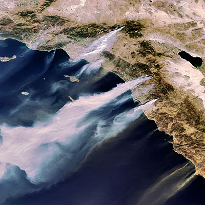
It's amazing that it's only been a week and the wildfires are already old news . Nevertheless, the NASA satellite images are remarkable:
These latest images, captured by NASA satellites on the afternoon of October 22, show the thick, billowing smoke coming off the numerous large fires and spreading over the Pacific Ocean. Fire activity is outlined in red.
The small white circle is the approximate location of our office. Downtown SD is on the bay just to the southwest. As you can see, the fires to the north and south didn't have much affect on us (and downtown) because the Santa Ana winds were blowing so strong directly from east to west.
The large fire area to the north (which started in Witch Creek) is heavily populated and is where most of the property loss occurred. That fire ended up getting to within several miles of the ocean. It's still hard to believe that over 500,000 people were evacuated from their homes.
I'm originally from the Midwest and thought tornadoes were bad -- hunkered down in the basement with the wind and rain battering the house and sirens blaring in the distance. Even if there were basements in CA I don't think they would help a whole lot in one of these fires. Your only option is to get out.
Here's another NASA image from about the same time (from here):
Wow!


Pingback: Canyon Fire: To Close for Comfort! | Bob on Medical Device Software